
Agro-Ecoregions Ken Meter Reports
Ken Meter’s reports include economics, food health, ranches and farms, land and sales, principal farm/ranch products, vegetables harvested by county, direct and organic sales, conservation practices, farm production balance, total crop and livestock sales, consumer expenditures on food, and more! Read them to become local and read them to know how to understand your own agro-ecoregion. For Livestock see the pamphlet or livestock section of this web site. For agro-ecoregions and crops, see Local, Edible Crops or page 20 of booklet. CLICK to download Ken Meter’s reports.
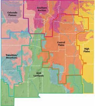
Map of County vs. Agro-ecoregion
Data are collected by Counties, which overlap only in part with agro-ecoregions. DNM has had to compromise and placed the whole county in the agro-ecoregion that best fit for land area and/or production. The table and Ken Meter reports list which counties are in which agro-ecoregions. A future dream might be that NM Department of Agriculture collect data by agro-ecoregion.
Download Map of County vs. Agro-ecoregion.
Agro-ecoregions
Southern Rockies Agro-ecoregion: Snow, Apples and Chimayo Chile
This is the agro-ecoregion of headwater streams of the Rio Grande and, in part, the Canadian rivers. Think snow. Farms are in mountains (mostly 6,000 to 8,500 feet) with a short growing season based on freezes, deep snowpack, snowmelt and spring runoff. It is the only agroecoregion with significant surface runoff. The growing season lasts between 100 to 120 days.
Elevation and slope are more important than latitude. The highest elevations have very short seasons (as short as 50 days with the threat of freezing at any time). Depending on elevation and slope, precipitation is from 17 to 55 inches, the wettest agro-ecoregion in the state. Farms may need windbreaks and mulches to protect plants that can perish from wind, freeze or winter sun. Fruit trees must be grown on slopes to escape cold air drainage. In some summers, despite the monsoons, high temperatures can cause droughts. At these times, the remaining runoff from snowmelt and shallow wells becomes crucial for irrigating. Wells tap into the valley aquifers fed by snowmelt.
The Southern Rockies is a heartland of Indo-Hispanic farm cultures with many legacy crops. Innovative projects — to regionalize food, aid local farmers, and feed consumers fresh and healthy food — flourish. Truck farms increasingly supply vegetables, fruit, meat and eggs to urban markets, farmers markets and Pueblos. Farms are comparatively small; many farms belong to acequia associations, and a few thrive within Pueblos and reservations (Picuris, Pueblo de Taos, Jicarilla Apache, Jemez, San Juan, Tesuque).
Nevertheless, 70% of agricultural income comes from cattle and sheep seasonally grazed on pasture, on montane grassland in spring and summer as well as on brushland. Grazing requires close cooperation among the Forest Service (Carson and Santa Fe Forests), former land grant families, BLM and the pockets of State and private lands.
Arid Lowlands Agro-ecoregion: Pecans, Chiles, Onions, Dairy and the Rio Grande
The Arid Lowlands produces more crops, nuts, and fruits than any other agro-ecoregion (94% of fruit/nut sales; 93% of orchard acreage; 59% of New Mexico crop sales). Chaves and Doña Ana counties dominate, but northern Bernalillo and Valencia counties produce grapes and potatoes, and raise horses in greater numbers. The southern counties grow chile, pecans, onions, pumpkins, watermelon and many vegetables. Otero has specialty crops like pistachios and sweet cherries. The Arid Lowlands is also the second largest producer of dairy and beef after the High Plains. Livestock feed on hay and graze the Chihuahuan grasslands.
The Arid Lowlands have been blessed and cursed with long hours of sunshine. Blessed by the longest growing seasons (220 days near the Mexican border) and cursed by high evapotranspiration (five to eight times greater than the rainfall, except at its northernmost edge near Albuquerque.) Rainfall is commonly 9.5 to a bit over 13 inches per year, the driest of agro-ecoregions. Think perpetual moisture deficits. The southern lowlands, the most distant part of New Mexico from the north Pacific, experience the smallest winter rains.
The Arid Lowlands has many differing landscapes: the Rift Valley of the Rio Grande, the mountains and
valleys of the Basin and Range, the Madrean Sky Islands, and the separate Lower Pecos section. There
are unfarmable areas like White Sands, the lava malpais and military bases; and areas limited to grazing
on BLM and State properties. Many of the soils need treatment for high levels of calcium carbonate
and salt. There are geothermal pockets that have spawned year-round nursery/greenhouse production.
To compensate for an arid climate, extensive water works have been built. The western part of the agro-ecoregion irrigates from the completely controlled lower Rio Grande; the eastern part from the equally controlled lower Pecos. These supplies depend on southern Rockies snowpack and State Engineer politics.
To provide irrigation security, farmers supplement surface water with groundwater — the western section from valley and basin-fill aquifers as well as a major limestone aquifer in Valencia and Bernalillo counties; the eastern section from another limestone aquifer (in Eddy and Chaves counties). The Tularosa Basin irrigates the exceptionally productive farmland and orchards near Alamogordo.
Colorado Plateau Agro-ecoregion: Cold Desert, Navajo Irrigation, Sheep & the Three Sisters
This is Navajo Country, but perhaps not as romantically envisioned. The San Juan River feeds the Navajo Irrigation Project with two dams, lift stations, canals and drainage works. It is the largest irrigated area (presently over 80,000 acres, scheduled for 110,000) in the agro-ecoregion with hay, wheat, tomatoes, cantaloupes and beans as commercial crops. Besides the Navajo Irrigation Project, irrigation is difficult. Most groundwater is typically 3,000 feet deep with little near-surface groundwater to help resource-limited farmers.
The agro-ecoregion is predominantly Navajo Nation and BLM lands with pockets of private and scattered State lands. It has two parts: the western plateaus with many unfarmable areas (mesas, shale outcrops, cuestas, and badlands); and the high intermountain valley (San Luis valley), which is counted in the Southern Rockies for economic data. The growing season is relatively short (120-155 days without frost) with a definite winter season (75 to more than 100 nights below freezing). The Colorado Plateau is semi-arid to arid (7 to 16 inches of precipitation) with relatively high elevations (4,000 to 7,000 feet). A cold winter desert. In addition, the Colorado Plateau — furthest agro-ecoregion from the Gulf of Mexico and blocked by the southern Rockies — has scant summer rain.
The Colorado Plateau has the highest percentage of income from harvested crops (74%), though not the most in cash receipts. Livestock income (26%) depends on irrigated hay and Great Basin shrub and Great Basin grassland. Traditional scattered, “dryland” (non-irrigated) farming features the Three Sisters (beans, squash and corn) and low-density sheep grazing.
High Plains Agro-ecoregion: Industrial Dairies, Cattle, Groundwater & Farm /Ranch Wealth
This formerly homesteaded agro-ecoregion, flat to rolling plains, once supported extensive plains grasslands and prairies of little bluestem. The prairie grassland now grows winter wheat for export and grain corn for the cattle and dairy business.
The High Plains straddles New Mexico’s eastern border and extends from the extreme south to the extreme north. Elevations vary from 4,700 to 7,000 feet. The growing season shortens from 220 days without freezing in the south to 120 days in the north. Snow increases from about 4 to 18 inches. The High Plains – closest to the Gulf of Mexico— receives 80% of its yearly rain in summer. The northeast section has the second largest number of thunderstorms in the nation. The agro-ecoregion sustains “dryland” (summer season rain) bean
farms, short season grain fields and rangeland.
The low rainfall (13 to 18 inches) pressured farmers to irrigate. The Ogallala and Roswell aquifers and water transfers from the Lower Pecos and Canadian River provide for irrigated agriculture. The central and southern High Plains now grow paprika, chile, peanuts, pecans, watermelons and other vegetables as well as all kinds of cattle feed (sorghum, hay, alfalfa, corn silage, grain corn). 40% of New Mexico commodity sales come from the High Plains.
The flat terrain, predominantly private lands with large pockets of State lands, is good for pasturing and growing grain crops; and the relative low humidity is good for outdoor and semi-confined Concentrated Animal Feed Operations (CAFOs). The railroad connections to America’s breadbasket as well as Midwestern CAFOs, feedlots and slaughterhouses facilitate even more grain and livestock trade. The High Plains support the largest dairy CAFOs with the largest herd sizes in the US.
Central Plains Agro-ecoregion: Sheep, Sunflowers & Caprocks
The Central Plains lies at the foot of the Rockies and slopes southeastward toward the flatter High Plains. The summer rains produce moisture for growth. At other times, it is too cold or too dry. (Average rainfall varies between 12 and 20 inches, depending on elevation.) Crop income is small (22% of total agriculture income), relying on hay (Union and Torrance counties), alfalfa and sorghum. Cattle, sheep and lamb raising — the most important agricultural activities — support themselves on brushland grazing, the irrigated feed, and plains grassland.
Most of the land holdings are private with sections of State lands and a few pockets of federal land. Many areas are unfarmable and ungrazable with solution-subsidence basins of karst, cap rock tablelands and steep escarpments. Irrigation comes from the Upper Pecos (Sumner Dam) and upper Canadian (Conchas Dam) and wells in the Santa Rosa aquifer, the Estancia Basin and the valley-basin fill of the Pecos.
Transition Mountains & Plateaus Agro-ecoregion: Rugged Land & Piñon Pines
The Transition Mountains is rugged; all lands are above 6,000 feet with short growing seasons (100 to 180 days) and large expanses of Forest Service property and the Mescalero Apache reservation. Small numbers of farms grow crops in isolated private properties with long distances to markets. There is no principal aquifer and the canyons of the Gila are so deeply incised that there are few extensive floodplains to grow crops. It is little surprise that this agro-ecoregion has only 903 farms and ranches (4% of New Mexico’s) and 70% of the farms and ranches are losers of agricultural income. In every recent year, commodity and livestock sales have decreased.
The agro-ecoregion has two parts: the Gila Basin (Mogollon mountains, Plains of St. Augustine, Black Range, San Mateo mountains, Pinos Altos range, Sierra Mimbres, Tularosa/Gallo, Zuni, Mesa and Ladrone highlands) and the Sacramento/Guadalupe mountains. Annual precipitation is 14 to 20 inches a year with snow between 16 to 60 inches. Both increase with elevation. Commonly, there are two distinct drought periods (April/May/June and September/October). Warm season evaporation is about three times precipitation.
Cattle and sheep (in Cibola) predominate with grassland, woodland and brushland grazing. Seasonal grazing occurs in a mix of montane and mixed conifer meadows, riparian vegetation, a fourwing saltbush extension of the plains as well as some Great Basin and Chihuahuan grassland. The extensive wilderness and forestlands of the upper Gila have caused friction between the re-introduced and endangered wolf and graziers.